0005-Airdex Traffic
Introduction
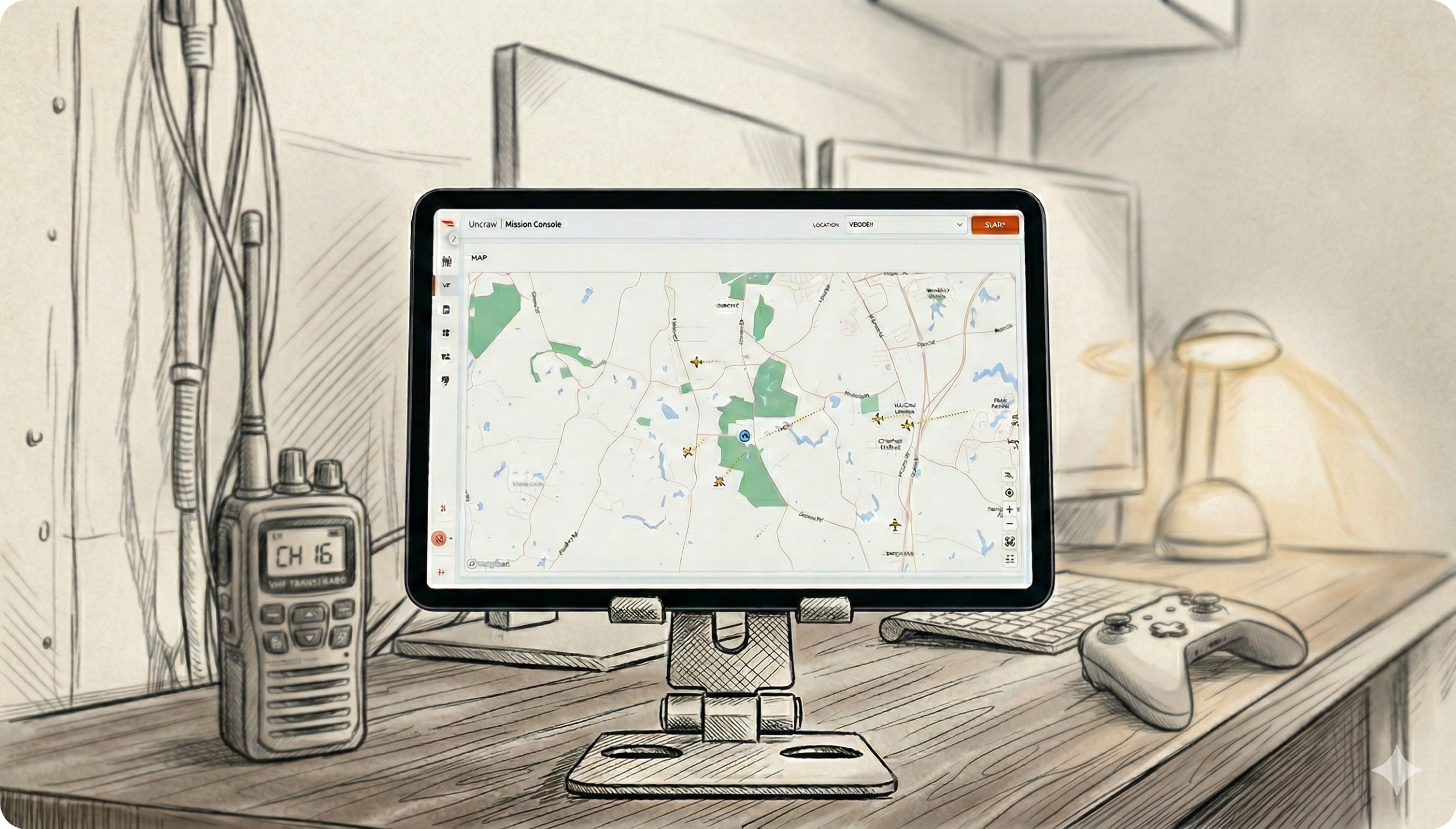
We are obligated to integrate with Airdex (a.k.a VA-FIX) for live air traffic information per the VIPC statement of work. We plan to provide a PoC feature in a non-production environment (dev) that shows the live position of air traffic as an advisory map layer.
Outcomes
This PRD is strictly limited to delivery of the Program Requirements and does not deliver a substantive outcome for our users. For example, this PRD will not result in the replacement of Flight Alerter, nor will it result in the removal of visual observers from operations.
Program Requirements
- Provide support for integration of ANRA Tools into the Virginia Flight Information Exchange (VA-FIX) including consumption of advisories and surveillance data and integration into ANRA airspace management functions, and sharing of data with VA-FIX.
- Integrate with Virginia Flight Information Exchange (VA-FIX) and other USS providers to use routes and share tracking and telemetry.
- Delivery no later than March 3rd.
Product Requirements
Air traffic positions shall display on the Uncrew map.
Shall use a single icon to display the last known position of the air traffic, regardless of air traffic type (e.g. manned vs unmanned).
- Air traffic should display with an unspecific, target-agnostic icon (e.g. target + heading). The icon should include a sub layer that lightly pulses between full and semi-transparency (e.g. 0 to 10/20% opacity).

Air traffic position information shall not be older than 10 seconds.
Air traffic heading shall be indicated. Air traffic messages that do not contain heading shall not be displayed.
Constraints
- The display of air traffic shall be used for informational purposes only and is not a basis for action.
- This feature will be a proof of concept. Its performance will not be guaranteed by any SLOs/SLAs, nor will it have on-call support. The feature shall not be deployed to a production environment without review and acceptance by Product, Engineering, and the Change Control Board.
- The information shall be limited to visualization of the live position of air traffic, but shall not include any details such as lat/lon or altitude.
- There shall not be any alerting based on proximity of air traffic to a user’s operation.
- There shall not be any indication of service health provided to the user, including outages, although the engineering team may configure liveliness alerts.
- Any malformed data will not be displayed.
- The display of air traffic shall be limited to Virginia and Pennsylvania.
- Air traffic shall only display in Uncrew’s mission manager view.
- There shall not be any guarantee of detection to display latency.
- We will not form or display tracks. Every air traffic position received from Airdex shall be treated as a unique plot.
- There will be no interpolation or smoothing of the display. Plots will be redrawn each time the integration polls for updates (every 5 seconds).
Operational Environment
We plan to access Uncrew Dev from a tablet that will live out of eyesight for our RPICs. When VIPC project sponsors ask to see traffic, a DroneUp team member will show them the tablet display. DroneUp RPICs will not work from the tablet. The tablet cannot be used as a ground control station for VIPC flights. It is for demonstration of the air traffic feature only.
Timeline
Prototype delivery must be completed during the week of March 2nd. DroneUp’s Managed Services team has requested a functional prototype before the end of that week.